History of the
O’Connell Valley
“…this place is worth speaking of as good and beautiful…”. 1
O’Connell – Why Is It Where It Is?
Governor Macquarie was accompanied, often daily, by William Cox around the Hawkesbury area to identify ‘safe and convenient’ situations for townships away from potential flooding. Cox played an important role in developing the five ‘Macquarie towns’ of Richmond, Windsor, Pitt Town, Castlereagh and Wilberforce. In December of 1810, Macquarie wrote that in Green Hills (later called Windsor), the farms
“…yield in this present time very fine crops, but the houses and habitations of the settlers are miserably bad…and liable to be flooded on any inundation… “2.
“Over the years the Hawkesbury’s fertility became exhausted. When the Cox’s moved there in 1804 it was not yet so. The soil was relatively fragile and was being overcropped by settlers who had no money or any kind of fertilizer, if they did not own cattle…Much of the Cumberland Plain was affected, while plagues of caterpillars (army worm) sometimes devastated crops”. 3
John Blaxland told Joseph Banks in October 1807 that
“a large portion of the farms [were] deserted, the buildings down or tumbling down, the poor creatures almost naked and many of them [with] nothing but maize to eat”. 4.
George Evans Diary – 6th December 1813
R. Cox, William Cox, Blue Mountains Road Builder and Pastoralist, Rosenburg 2012 p.90
Ibid p93
Ibid p93
Historical Records of Australia, Series 1. Governor’s Dispatches to and from England; Volume V111 July 1813 – December 1813. The Library Committee of the Commonwealth Parliament 1916. (pp 118 – 123)
The journal text follows the original spelling and punctuation, resulting in the frequent use by Evans (and others) of capital letters for objects of importance.
Why Cross the Blue Mountains?
Governor Macquarie gave his reasoning in a dispatch to Earl Bathurst, in London, after the event.
Governor Macquarie’s Dispatch to Earl Bathurst,
Sydney, New South Wales, 19th January 1814
“My Lord,
The Drought and Consequent Deficiency in Grass and Water for the Cattle,…led me to make an Effort at the discovery of some Track of Country where Possibly Nature might be more bountiful than in the present Circumscribed Limits of this Colony; and in furtherance of this object, I some Weeks ago gave Instructions to Mr. Evans, one of the Deputy Surveyors of the Land, attended by a few men and provided with the Necessary Accommodations for a two Months Tour, to proceed in the Attempt of Affecting a Passage over the great Range of Mountains, called here “The blue Mountains”, and to discover what Description of Country lay to the Westward of them. The Consequence, I am most happy to Inform Your Lordship, has been that at a distance of 150 Miles Mr. Evans has a discovered a beautiful and Champain Country of very Considerable Extent and great Fertility, thro’ which a River of large Size, abounding in large and very fine Fish, takes a Westward Course. Mr. Evans has brought with him some Specimens of the Timbers, Stones and Minerals, which he happened to fall in with, but I am not yet enabled to state what Importance may be attached to them, tho’ I am inclined to think that some of them may prove of very great value. Neither am I enabled from the very recent return of Mr. Evans to give Your Lordship at this time a more minute account of the Success which has attended this Tour of Discovery. I am however fully persuaded that this hitherto unexplored Region will at no distant period prove a Source of Infinite Benefit to this Colony. In my next Dispatch I shall do myself the Honor to transmit your Lordship a copy of Mr. Evans’s Journal with every other Circumstance attending the Discovery that may come to my knowledge and be worthy of Your Lordship’s Consideration.
I have, &c.,
L. Macquarie” 5
Blaxland, Wentworth and Lawson were not the first to attempt a crossing of the Blue Mountains. They were preceded a decade before by Lieutenant, Francis Barrallier, who failed as did Bass. George Caley, the botanist, with four soldiers and five convicts failed when stopped by a huge waterfall. He had penetrated 100 miles from Nattai. (near Mittagong). What was to come was the most significant of the attempts.
Gregory Blaxland, William Lawson and W.C. Wentworth started their expedition in May 1813. Their expedition terminated at a point west of present-day Hartley at a prominent sugarloaf hill, later named by Evans as Mount Blaxland. 6
Six months later, Governor Macquarie directed George Evans
“…to proceed in Attempt to Effecting a Passage over the great range of Mountains and to discover what Description of Country lay to the Westward of them”. 7
On Saturday 20th November, Evans set off from Emu Ford with two free men, Richard Lewis and James Burns and three prisoners, John Coogan, John Grover and John Tygh. They carried provisions sufficient for two months on packhorses.
Evans was instructed to survey by chain and compass the route taken by Blaxland, Wentworth and Lawson and of his own route beyond the base of Mt York. He delayed the survey from Emu Ford to move more quickly while the horses were fresh. He made Mt. York on the fifth day where the party camped to rest the horses.
Evans commenced his survey westwards on 26th November from a marked tree and followed the Lett River to the Cox’s River. When they reached Blaxland’s terminal point, he recorded in his journal
“I stopped this evening near the foot of a very handsome Mount, which I take the liberty to call Mount Blaxland, also two peaks rather north of it, and which the Riverlett separates, Wentworth and Lawson’s Sugar Loaves” 8
He departed Mt Blaxland on November 24th and camped for the night at Jock’s Creek, near “Cheetham” (Rydal district). Evans wrote on November 29th
“I stopped in very bad Spirits, not being able to get on, being completely entangled among the hills, and our horses being so little Westing; were it not for the Horses the difficulty to ourselves would be nothing, they are sometimes bad to manage, and soon tire among the high Lands, when so they will not move.” 9
They had travelled only six miles in three days, but the crest of the Great Dividing Range had been reached. On November 30th he headed towards Antonio Creek to reach a ridge on the summit and named it Clarence Hilly Range.
“I was much pleased with the sight Westward; I think I can see 40 miles which had the look of an open Country”. 10
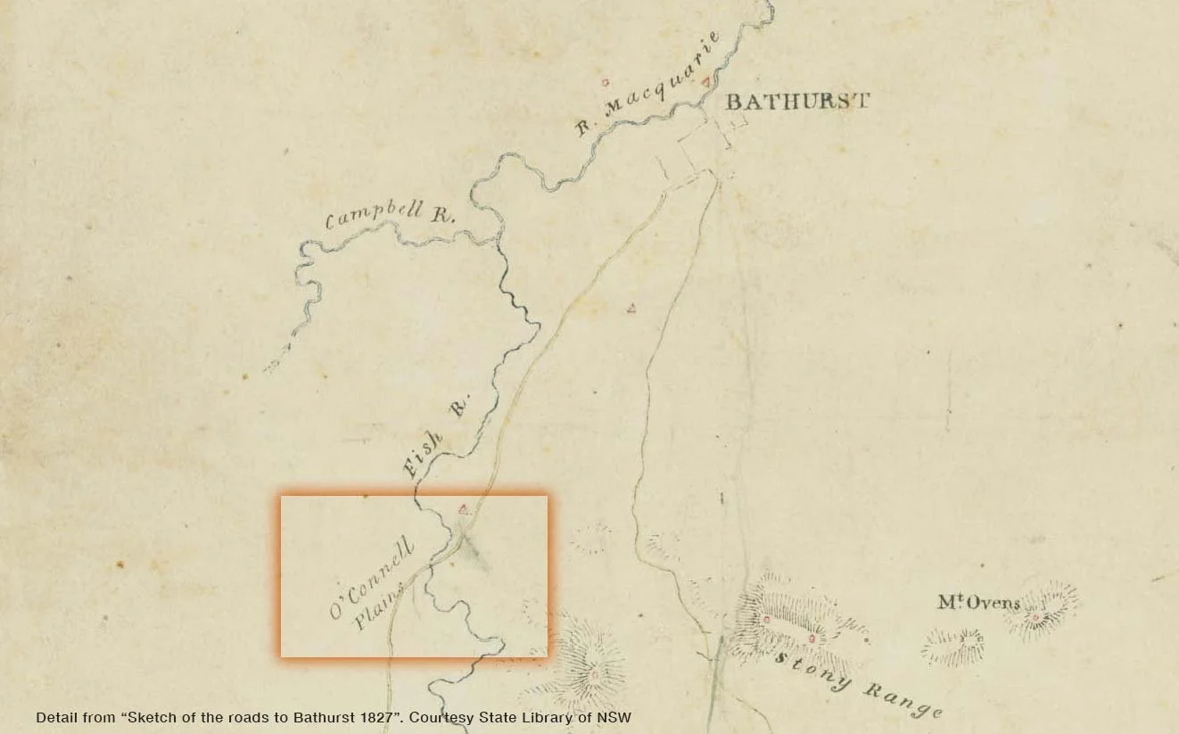
From Clarence Hilly Range Evans descended southwesterly and encountered the first inland flowing river seen by Europeans from a point northeast of Bindi Hill. This stream he named Fish River, so impressed was he with the size and plentiful supply of fish.
He proceeded along the left bank of the Fish River and on December 1st he passed an unusual “sugarloaf” hill and put his own name on it. When he reached the confluence of Solitary Creek he wrote
“I think it is equal to Van Dieman’s Land. The river winding through fine Flats and round the points of small Ridges that gradually descend to it, covered with the finest grass and intermixed with White Daisey as in England”. 11
Friday 3rd
“I now find Memosa in clusters on the Banks of the River; am happy to think it favours me so much as to run the course I wish it; the Country continues good, particularly for grazing, yet it has not been altogether pleasing to the Eye as before, being in some places rather overrun with a shrub among the Grass,…the land is still of a light sandy nature, thinly wooded with small gums. We have not seen any Natives but can see their late tracks.”
Saturday 4th
“My progress is through an exceeding good Track of Country; it is the handsomest I have yet seen with gentle rising hills and dales well-watered; the distant hills, which are about 5 Miles South, appear as Grounds laid out divided into fields by edges, there are few Trees on them and the Grass quite green; I still keep the river, and at times I walk a few Miles South or North as seems to me most requisite. The Dogs killed a Kangaroo and the river supplies us with abundance of Fish.
Sunday 5th
“The night was very wet; we were uncomfortable having no means to shelter ourselves from it, as the trees will not bark; it has rained most of the day; about 4 o’clock a violent Thunder Storm came on, the clouds seemed to disperse, wind blowing fresh from the West. We remained near the River as it is Sunday. The Horses are getting fat but am sorry to observe their backs are sore; the Saddles should been lined; straw stuffing is too hard to render it easy we put our blankets under them; I walked out this Evening some Miles; I cannot speak too highly of the country, indeed I am now at a loss what to say as it exceeds my expectations and daily gets better. We are on an Allowance of Bread having lost so much by the bad Weather on the Mountains, we require little pork in this part, a Kangaroo can be procured at any time, there are also Emu’s, we killed some Ducks this day.
Monday 6th
“The Night was very Bad,…this morning had a better appearance; the river now forms large ponds; at the space of about a Mile I came upon a fine Plain of rich Land, the handsomest Country I ever saw, it surpasseth Port Dalrymple; this place is worth speaking of as good and beautiful; the Track of clear land occupies about a Mile on each side of the River, I have named it after the Lieutenant Governor O’Connell Plains, on which we saw a number of wild Geese but too shy to let us near them; the Timber around is thinly scattered, I do not suppose there are more than ten Gum Trees on an Acre, their Bark is amazing thick at least 2 inches; At 3 o’clock I stopped at the commencement of a Plain still more pleasing and very Extensive; I cannot see the termination of it North of me; the soil is exceeding rich and produces the finest grass intermixed with variety of herbs; the hills have the look of a park and Grounds laid out; I am at a loss for Language to describe the Country; I named this part Macquarie Plains.”
Evans had continued west to the Campbells River, near what is now The Lagoon, then north to the junction of the Fish River and Campbell’s River to become the Macquarie River, then on to the Bathurst Plains.